
Mt Isolation via Pinkham Notch
Many twilight trail runs and summit sunrises were had while trekking the road to our good friend Chris finishing his round of New Hampshire 4000-footers; today would be significant in that we would aim to stand atop his 48th high peak in the White Mountain National Forest. A larger, lifetime achievement of trail running all paths contained within the AMC White Mountain Guidebook served as an outline for adventuring to, and seeking new areas of our vast wilderness. This morning, we would hopefully check off several more paths around the Presidential Wilderness, as well as close the book on his ramble to stand atop all of the recognized summits which top 4000-feet.

Chris, making his way to the alpine
Beginning from the Pinkham Notch Visitors Center, we met around 3am, readied headlamps in the cool, morning air. Overhead, innumerable stars illuminated the otherwise blackened sky; cloud cover was on our side, much less than forecasted - perfect in which to watch the dawn of a new day - sunrise from the alpine, sounded like a fine way to spend a Wednesday morning!
From the southern end of the hiker parking lot, at the Pinkham Notch Visitors Center, we turned on headlamps, threw loaded packs on our backs, and listened for our cars locking behind us. Onto the yellow-blazed Direttissima Trail, we began, almost immediately crossing the Cutler River on a well-constructed footbridge. Paralleling the Pinkham Notch Highway (NH Rt 16), the Direttissima was laid out and cut between 1969-1971, as to offer hikers a forested reprieve from trekking along the shoulder of the main highway. Along the west side of Rt 16, this rugged path rolls past magnificent trailside boulders, and skirts through the upper west-end of a gorge. Climbing alongside a minor cliff, we chose our footing intentionally when on wet boulders. Crossing several inconsequential brooks enroute, we inevitably missed our junction with the Glen Boulder Trail; with headlamps pointed at our feet, we continued several rods onto the Avalanche Brook Ski Trail, before recognizing our error - this was quickly fixed.
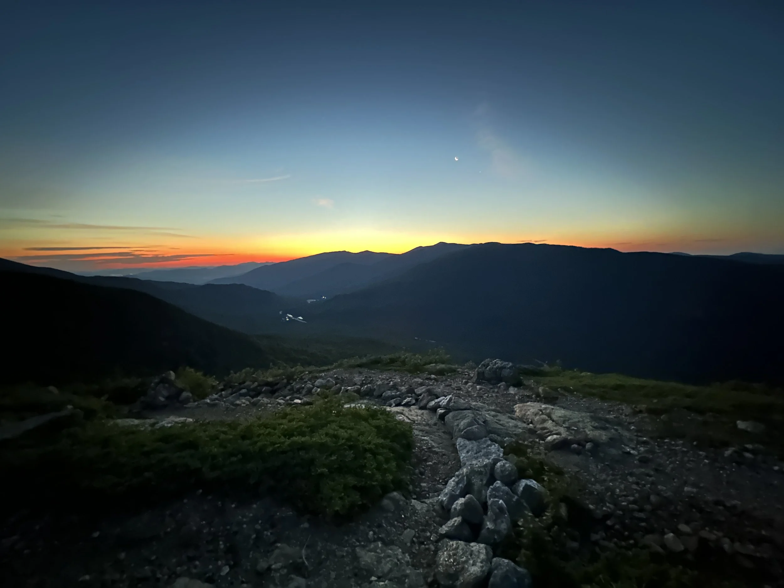
Approaching sunrise along the Glen Boulder Trail
Alongside a tributary to the Ellis River, the Glen Boulder Trail wasted no time gaining elevation. With rocky, but stable footing, the pathway gently switch-backed several times while enroute to the alpine. Through the treeline, we climbed steadily, eventually reaching the base of a precipitous, rocky scramble - essentially, our gateway to the ledgy alpine zone.
While picking a good line, with sturdy footing and solid handholds, I could hear Chris exclaim something about the Carter Range, just behind my shoulder. Upon passing the warning sign, advising we were indeed, already entering the alpine at about 3,480’, I caught a glimpse of sky fire over those eastern peaks. Perfect timing: a deep burgundy-hue shone from behind the 4,839’ Carter Dome, transitioning into oranges and blues, before melding with the dark, night sky; one speck of moon sliver broke the colorful horizon, just above the peak.

If its listed in the AMC Mountain Guide, it must be trekked!
Following rock cairns and scree walls, we meandered along the open ledge, with low conifers offering a blanket of scrappy, green vegetation; massive boulders lined trailside - but none were as significant and daunting as the immense stone we could see just up ahead - the Glen Boulder!
How precarious this chunk of granite sat on the end of the mountainous spur, as if with one gust of a winter gale, it might topple into the notch below. Even while driving through Pinkham Notch, it is an impressive sight looming above, but none like standing at its base and peering up; it is truly a monumental sight to behold. By now, the ball of morning sun had risen enough to illuminate all around; headlights became unnecessary, allowing for eyes to adjust, even further enhancing the stunning array of sherbet coloring, which streaked across our morning sky.

Sunrise over the Carter Range
As we waited for the sun to crest from behind eastern mountain ranges, we continued climbing steeply atop open rock ledges, being diligent to avoid localized patches of small, delicate alpine flowers; the quartzite-streaked granite was much more grippy anyhow. Every few rods, we would pause to look back eastward, being sure to catch the pivotal moment when the orb of sun would crest, further illuminating our surroundings with the sweet, reddish hue of alpenglow.
With perfect timing, we traipsed back into the cover of scrappy conifers, but not before the headwalls of Tuckerman Ravine and the Gulf of Slides were bathed in low-angle morning light. Re-entering the high scrub, the footpath tapered to a minimal incline; for due diligence and trail red-lining purposes, we ventured down a brief spur path (~40-yards) to a natural spring and back. As the stiff conifers grew tight, hugging the footpath, we meandered ever closer to Slide Peak (Gulf Peak on some recent maps), which is the head of the Gulf of Slides wall.

Chris all aglow - climbing the Glen Boulder Trail
Emerging yet again from the evergreen, we had given the rising sun just enough time to display all of its true magic - the cascading layers of subsequent mountain ranges were truly breathtaking. Rock hopping was the mode of travel as we swung northbound, around the Gulf of Slides, enroute to rendezvous with the Davis Path, southbound. The narrow band of trail cut deep into the alpine vegetation from years of foot traffic - this was appropriate, forming a durable surface for funneling foot traffic atop pebbles and inorganic soil; however, we cringed at each and every unnecessary herd path encountered - most of which displayed trampled vegetation and uncompacted organic soil which would just erode further, from lack of roots tying it all together.

A great day to run alpine trails!
Glancing back often, the narrow ridgecrest appeared as a forested spine, still deep in morning slumber. Finding the white USFS/AMC signage, we searched the southern landscape, speculating our next destination: Mount Isolation, but none stood out as the obvious high point. Descending rapidly along the rocky, northern Davis Path, we bounced once again from rock to rock, ensuring durable footing was underfoot at all times.
As the Davis Path dove back into the coniferous canopy, I turned to glance along the southern tail of Boott Spur; somewhere in the mix of shattered rock, we were transitioning onto the Montalban Ridge for a wooded descent into the North Isolation col. Atop a crumbling, earth and rock footpath, we dropped to roughly 4,180’ - still much higher than our penultimate destination!

Soft footing of the Davis Path
Mileage went quickly along the winding Davis Path; several instances of nearby blowdown patches afforded glimpses back northeastward, to the shoulder of Slide Peak; a stark reminder of how far we had dropped, and how far we had yet to climb back out! Ferns lined the dark, dank, Davis Path; occasionally, footing was atop old, disintegrating planks of boardwalk. Oftentimes, rich, blackened mud rose up and over the boards. It is interesting to my mind, to imagine the well-graded Davis Path of yesteryear. Originally, cut as a bridal path in 1845, the path is said to have only been in use for only nine-years, later being re-opened by the AMC in 1910, having become highly obscure during its disuse. Now, the Davis Path is a pleasant stroll, now resembling an iconic - rocky and rugged - east coast foot path.

Presidential views from the summit of Mt Isolation
Passing trail junctions for the Isolation Trail, we received a sense of extreme remoteness, finding no other hikers out exploring (ie: gridding) Mount Isolation. Upon reaching the brief spur path to its high point, I still recall the days when a small, wooden sign indicated this path to be the final, steep climb to obtain the summit of Mount Isolation. Allowing Chris to make his ascent first, this was just appropriate while on the final summit of his 4000-footers quest; we scrambled up a mini-chute of rock, where we topped out on bare ledges with low conifers. Views in all directions abounded as we made the final stroll to the significant rock pile and adjacent, three USGS survey benchmarks.
Sweeping views from Mt Washington, to the southern Presidential mountains all baked in the morning sunshine, a vantage I have yet to grow accustomed to, despite this being my fourth summit of the mountain (winter-48 finish up here). After several photo opportunities, high fives, snacks and refreshments, we turned to retrace our steps - this time, northbound along the Davis Path - our morning run was hardly half complete.

Davis Path; a forested tunnel
The climb along the Montalban Ridge northbound was not necessarily a steep ascent, just a long and steady climb. Over rocks, we once again followed massive rock cairns back into the open, alpine zone - it felt good to be back in the sun after traversing the cool, wooded, Davis Path. After packing out a bandana someone had tied to a chunk of quartzite (LNT), we pressed on, quickly reaching the Glen Boulder Trail junction at ~5,180’. Views in all directions continued to take our breath away, photographs failed to capture exactly the feeling we soaked in from such lofty heights.
Ascending around a massive, craggy bulge, footing was now atop shattered rock, most of which were stable, and overall locked in place. Drawing near to the Boott Spur, finally, Mount Washington with its ghastly summit towers came into view; what impressed my eye more than that over-built rock pile was the glimpse into Huntington Ravine: streaks, cracks, and crags all billowed up out of its gully.

Approaching Boott Spur
Turning eastward, we struck off the Davis Path atop more shattered rock, toward the summit cone of Boott Spur, departing briefly the Boott Spur Path, in which to locate its true high point. This mass of rock is a prominent ridge running south from Mount Washington, connected to that formation of jumbled rock by Bigelow Lawn; many early ascents were made via this rugged route. In descending, we quickly lost sight of the tip top of Boott Spur, as we bounded between scree walls, down step-like levels and slopes, eastward.

Mt Washington from near Boott Spur
Views toward both the Wildcats, Carters and into Maine were fantastic, as were those which began to appear into both Tuckerman and Huntington Ravines. Before long, we could glance back toward the Tuckerman headwall and spot a chute of water cascading - the start of the Cutler River. At several instances along the exposed descent, we encountered various lookout spurs, mostly sweeping north, northwest, and northeastward.
Upon passing the Boott Spur Link, I recalled noting old maps where this precipitous footpath was the only Boott Spur Trail. Today, we continued eastbound along the spur ridge, along the Boott Spur Trail, passing several stunning outlooks, and with a quick visit to the iconic Split Rock - another massive stone which has invariably split in two, allowing hikers to walk inside. Shortly after this attraction, we followed short scrub back into treeline, where we followed indiscernible, old logging and tote roads over mostly pleasant, albeit rocky footing.

Descending the stepped terrain of the Boott Spur Trail
Noticing a broken, white AMC sign indicating an Outlook; treading lightly, we took this briefly until recognizing the vista had grown back in - likely why there were downed sticks blocking the old herd path. With several, final glimpses back toward Mount Washington and its deep ravines, we began a steep descent with massive rock walls and boulders, at one point utilizing a tall, wooden ladder to safely descend.
Swinging now, from eastward to a northerly course, we passed over the overgrown John Sherburne Ski Trail, and within several rods, found ourselves on the familiar, wide and rocky, Tuckerman Ravine Trail. As the morning sun loomed overhead, several parties were basking in the pristine waters of Crystal Cascade, a marvelous spot to cool oneself off following an alpine jog.

A farewell to the alpine - see you soon!
The time was nearing 9:45am, many hiking groups began their trek as we continued to use the light, down-sloping grade to our advantage. Before long, the structures and commotion of Pinkham Notch began to fill the still, mountainous air. Another fantastic ramble in the alpine for Chris and I; another list inadvertently complete, on his quest to run the entire AMC Mountain Guidebook. A fun, languorous goal, which I can fully support.
Finding new places to explore, should be, after-all, the spice of life, should it not?
Happy Trails, Chris - Thanks again for each and every invite!
Overall stats for the day:
13-miles
6hr 28 minutes
5,856’ elevation gain
Mount Isolation - 4,004’
Boott Spur - 5,499’ (+/- depending on source)

Chris, looking around for the so-called Split Rock