
Mt Adams via Kings Ravine
Six years ago while exploring more unconventional routes of the White Mountains, my brief obsession with the Northern Presidential mountains had found me roaming into King Ravine. Being interested in the history of these hills and drooling over the pages of Rev. Thomas Starr King’s 1859 publication entitled: “The White Hills: Legends, Landscapes, and Poetry”, this massive gully demanded my attention even back then.

Beginning along Lowe’s Path
Having exited the King Ravine via the Chemin des Dames route during that initial ramble, ever since, the notion plagued my mind that I had exited too early - I wanted the full experience. Today was the day for that return trek, to make an end-to-end go at the King Ravine via the King Ravine Trail. I personally think, while I could have made the rugged, bouldery accent using great care, back in my early days of living in the White Hills, having the experience of climbing and scrambling in numerous mountain ranges across America since, no doubt brought improved climbing technique, allowing for a much better and safer overall experience.
Planning to begin from the same parking lot as that 2018 ascent, I was enthralled to find the latest (2022 printing, 31st Edition) edition of the AMC White Mountain Guide listing the abandoned, Lowe’s Store parking lot as optional (free) hiker parking - this would cut off unnecessary, flat mileage along the Presidential Rail Trail enroute to my initial ascent route - Lowe’s Path.

Arriving as planned, at first light, gear was readied as the small Ball jar of overnight oats Alanna had prepped was finished. Being the sole car in the overgrown General store lot, I began the brief road walk to catch the northern terminus of the Lowe’s Path. Cut 1875-76 by Charles Lowe and Dr William Nowell (descending his namesake ridge today) as a toll path for its first four years; in present day, hikers can find several restoration projects going on at multiple over-trampled sections of the trail’s mid-region.
Immediately, into dense northern hardwoods I began, considering whether digging out my headlamp was the way to go, but knowing the morning sun was quickly rising and illuminating the clear sky above, I stubbornly pressed on - not without assuming each and every up-turned root ball or stump was a resting moose or bear, until proven otherwise.

Beginning along the King Ravine Trail
Alternating footbed of stepping stones and beautiful, soft footing, there were many sections of mud or soggy trench - this was no doubt trekked through when well-placed stones were not available, as to not unnecessarily widen the saturated trail. Mindfully, I had given the King Ravine a full day of sunshine to drain and dry out before this ascent, apparently this run-off was still making its way down sections at lower elevation; however, it was clear any water-bars were certainly doing their intended job - the trail work along the Lowe’s Path is simply stunning, but may be time for upkeep.
Crossing brushy ski or logging roads, in short order, the gravel-surfaced Presidential Rail Trail, then the grassy powerline swath were also behind. Now began a beautiful stroll through standard northern hardwoods. Having been logged extensively along their lower mountainous slopes, thankfully, many massive, trailside birch remain to quietly greet hikers, their bark well transitioned into the later stages, appearing significantly old and wise.

Passing Canyon Falls on the King Ravine Trail
Up rock steps, the fern and hobblebush-edged Lowe’s Path gently swings around several massive boulders and brooks, gradually up inclines in the lower hillside as it passes a connection with The Link path. Continuing straight through this junction for roughly 0.1-mile, our path splits; with the King Ravine Trail veering left, my descending route, the Lowe’s Path, continues more southwesterly, to the right.
Footing early along the yellow-blazed King Ravine Trail was surprisingly outstanding: a soft, earthen trail bed guides hikers toward King Ravine via an eastern spur of Nowell Ridge, through stunning woods, the trail rolls generally eastbound before swinging directly into King Ravine. Trailside trees appear overall a narrow, similar diameter - indicative to my eye that either logging or some other natural event had all but wiped the slope clean in prior years. Before long, the pathway begins to descend, crossing Spur Brook with a stunning waterfall known as Canyon Fall, on climbers right. Swinging to parallel the brook, before long, the Amphibranch Trail and Randolph Paths all convene - white RMC (Randolph Mountain Club) and USFS (US Forest Service) signage help guide hikers in their intended direction.

A sense of remoteness entering the ravine
As footing becomes rocky, the sound of Cold Brook increases, echoing off the ravine walls. Crossing this waterway can be dicey in times of high water, even today, with a slight haze drifting off the chilly torrent, mossy rocks were slick, but a safe crossing was made about six-feet left of the actual trail, on sturdy boulders. Once across this beautiful brook, many cascades can be enjoyed as the King Ravine Trail parallels east, enroute to meet the Short Line Trail.

Trailside, Mossy Fall, entering King Ravine
A small RMC sign indicates Mossy Falls just off trail, this gem should not be missed. With a sense of increasing remoteness, the King Ravine Trail begins a moderate climb through broken boulders - some the size of sheds or small houses - truly an impressive sight to behold! Before long, the second warning placard comes into sight (the first, at the onset of Lowe’s Path, warns that hikers must be in top physical shape to attempt these trails), providing awareness of parties entering the alpine zone, as well as a general insight as to the extreme ruggedness of the ensuing section of trail, and if the weather appears foul, turn back now.

Becoming increasingly rugged along the ravine floor
With clear skies overhead, I began scrambling over broken, haphazardly stacked boulders, employing hands for balance. Turning one corner, a glimpse of the King Ravine headwall comes into view; eventually, upon scaling one massive boulder, a slight lookout toward the northern region can be had, showing climbers how far they had climbed out of the valley - but still such a distance to climb.
Narrow chasms and chutes guide hikers over the varying terrain, on a dry day, such as this, the craggy granite was grippy for La Sportiva trail runners, handholds were not difficult to find, although I was picky with where I trusted hands or feet during this entire climb. In several instances, the trail alternates between exposed rocky ledge climbing, and brief dips back into forest strolls - more frequent than I had recalled from my first ascent, but welcome nonetheless.

Up and over broken blocks as views begin
As the Chemin des Dames route veers eastward, toward the ravine wall, I followed the King Ravine Trail, often blazed with a rusty red-orange hue, which (in my opinion) could easily be mistaken in many instances for patches of red algae on the rocky surface. Rock cairns do not appear until much higher along the headwall, care must be taken to remain on route, several spots were tricky, but totally manageable in regards to route finding through the ravine floor.
Opting to forego the Subway route today, my objective was simply the King Ravine Trail in its entirety - although, even this route featured at least one instance where I was crammed into extremely tight quarters - shimmying under, or between large boulders. I laughed to myself when I saw one sign which indicated my intended route as “easier”, no doubt it might be when compared to cave crawls found on the Subway route.
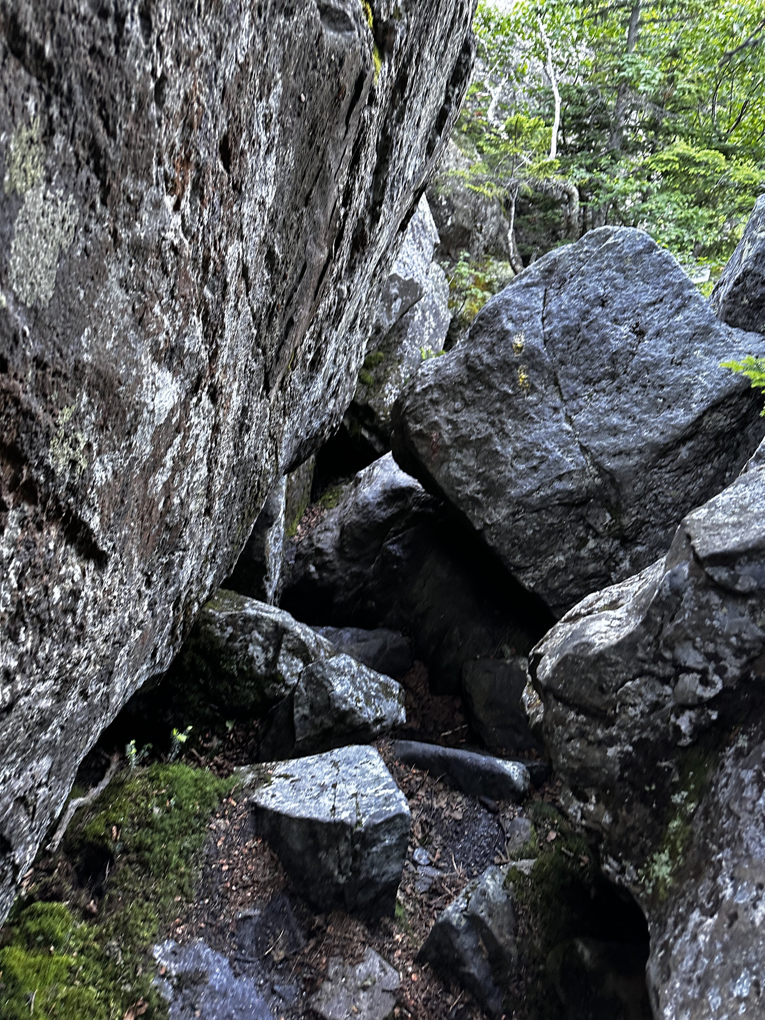
A few tight crawls approaching the headwall
Passing the diverging Great Gully Trail, I once again found myself submerged in a dank, mossy forest; footing remained solid, albeit rocky in the wooded stretches. The King Ravine was nothing short of impressive, with significant boulders lining the gully floor, the trail felt like none I had hitherto experienced in these White Hills.
Scrambling atop shattered boulders, in many instances, glimpses 10-20ft down can be had; another hiker had inquired later in the day, but I did not notice any remaining snow within the deep voids. Once out of the high scrub, the ascent takes place entirely on stacked, broken boulders - a product of frost action weathering and old glaciation, perhaps? Climbing steadily now, along the headwall of King Ravine, with good intent, I only glanced up to the coming terrain to ensure I was not travelling head-first into any jarring sections of granite; focus was placed entirely on the several surrounding steps - remaining completely present and diligent.

Not all boulders are locked in place!
Any flat boulder offered a chance to slow, glancing back northward, or taking in the sights of the impressive western wall of the ravine, exposed rocks and ledges have proven impossible for vegetation to take hold. Massive boulders became smaller as I climbed up and out of King Ravine, in one section even reminiscent of the South Slide of Tripyramid; loose scree with microwave-sized boulders were not exactly what I had in mind for a harrowingly steep slope such as that. Every chance I had, I worked to remain atop the larger, more locked in place, stones - anything which could clearly bear my weight without shifting.

Some loose footing approaching the upper climb
Rock cairns soon aided in route finding, although not entirely needed for my navigation, it was a game of picking solid footing while simply climbing out the massive chute: climbers right offered a glimpse of what I assumed to be the old “rock climbers wall”, while my left showcased towering, craggy boulders several stories tall - this morning, I was obviously playing it safe while taking the path of least resistance.

The final chute enroute to the Airline Trail
As I stepped foot onto the Airline Trail, the mighty Mount Madison popped into view - and what a sight it was, a dark, billowing cloud had begun rising from the east, behind its pyramidal summit cone. As localized as this lofty cloud appeared, I honestly questioned to myself whether it was cloud or wildfire smoke - undeterred, I pressed on toward the pack of Adams peaks.

John Quincy Adams summit bolt, Mt Madison behind
Having been to the summit of John Quincy Adams once before, I opted to make the brief bushwhack to the peak of this narrow, shark-fin shaped rock pile. Remaining entirely atop shattered boulders, I knew better than to use the soft footing of fragile alpine vegetation (especially the high altitude grasses!). After scaling the 5,410’ peak and questioning the elevation of a nearby summit crag, I opted to traipse over to that rock pile as well - here, I found the silver bolt embedded in the highest rock - the recognized summit!
As I continued watching the cloud looming behind Mount Madision, more haze began rising from the depths of Madison Gulf. Now, I was convinced what had concerned me moments prior was thankfully not wildfire after all. With quick footing, I bounded down jagged rocks, back to the Airline Trail, which would guide to the summit of Mount Adams.

From Mt Adams: JQ Adams, Star Lake, Mt Madison
Generally, following waist-height rock cairns, my approach to this climb was more-or-less just remaining on jagged boulders with the most solid footing - off any alpine vegetation, which was flowering during my ramble through this higher terrain. From my previous peak, I could spot other hikers ascending in brightly colored jackets, they were long gone by the time I reached the second highest rock pile in the state, having the summit once again, all to my own.

Mt Washington (left), Mt Jefferson (right), from Mt Adams
Finding the silver bolt atop the second highest peak in New Hampshire, I briefly soaked in the 360-degree vistas before turning to follow the Lowe’s Path, westbound off the summit of Mount Adams. Greeting 3-backpackers from North Carolina, we chatted briefly as I continued to monitor the billowing cloud overhead, appearing now like a mushroom cloud of significant instability; knowing the afternoon, as well as the forthcoming days were calling for storms, I hastily, yet carefully picked a route off this rugged mountainside to Thunderstorm Junction below.

From Lowe’s Path: into King Ravine, Mt Madison behind
Opting to forego a visit to 5,585’ Sam Adams (visited during a 2018 ascent), I continued along the bouldery Lowe’s Path enroute to the next fin of angular boulders; a brief scramble brought me to the remote, 5,355’ summit of Abigail Adams (Adams 4, prior to 2010) for a much needed refuel of dates, nuts and seeds. After roaming around the summit rocks of this minor alpine summit, remaining diligent to cautiously step atop sturdy rocks, it was back to the Lowe’s Path, which I would follow back to the namesake store, where I was parked far below.

The rocky wave of Abigail Adams
Following Nowell Ridge, this old path meanders in more-or-less a straight shot through alpine grasses, eventually giving way to short scrub, which grew in frequency as elevation was gradually lost. Making a game of whistling back to any birds which sung out nearby, I could gaze far out into the horizon, broken by the Kilkenny Ridge and several lesser summits in the foreground - absolutely incredible views abound as one slips beneath 5,000’, eventually rejoining tree-line near the junction of the Gray Knob Trail.

Down Nowell Ridge, Lowe’s Path
Before long, I recalled well the rugged, damp footing of the Lowe’s Path; mossy, wet boulders slowed the pace somewhat as care was needed to safely descend the wooded ridgecrest. Nearing The Log Cabin (RMC maintained), flagging began appearing in several sections - unsure of its purpose, it became apparent when noticing pulleys and guy lines high overhead - trail reconstruction projects were underway by the Randolph Mountain Club in some of the more badly worn and widened sections of this trail.
Footing remained slick and wet for much of the coming descent, over mossy boulders and ledges, most with obvious places for safe footsteps, it was easy to tell how badly widened the trail had become, however; likely during “shoulder-season”, when the ledges and rocky bulges were covered with ice - hikers going far around to avoid slick sections will tear up fragile soil with spikes and crampons, thus encouraging further degradation and travel.

A slick slab descending Lowe’s Path
Once footing dried out somewhat, I was completely unaware that the cut-off for the King Ravine Trail was behind me - I was rapidly losing elevation with the quickened pace allowed by more solid footing. As altitude was lost, the heat and humidity crept back in, it was like a green tunnel beneath the hardwood canopy. Past the grassy swath of powerline cut, beyond the Presidential Rail Trail - the old Lowe’s Store was quickly approaching.

Smooth sailing + good footing of lower Lowe’s
Once roadside, I could glance far into the mountains from whence I came, to see an ominously dark cloud looming over those higher summits, glad to have been rewarded with the magnificent vistas of 8am, a big bowl of watermelon hydrated and solidified a stunning morning of alpine running and rambling - I had all but forgotten today was Monday.
Overall stats for the day:
9.77-miles
4,905’ elevation gain
5hr 39 minutes
John Quincy Adams - 5,410’
Mt Adams - 5,797’
Abagail Adams (Adams 4) - 5,355’