
Bigelow Ridge: FWT + AT (2024)
Five years had passed since stepping foot into the Bigelow Mountain Preserve; to hike and trail run along this glorious ridgecrest, which is comprised of many bald peaks, moss and fern-lined paths, and babbling brooks - all of which are surrounded by unbroken tracts of spruce and fir forests. When the notion of paying a return visit to this stunning, remote wilderness fell into the planning phases, with Alanna working on visiting the four-thousand-footers of this great state, I was quick to jump on a return revisit. I was curious how this forested landscape may have been altered, or what aspects might now stick out, details which were probably overlooked during my peak-bagging days of yesteryear.

Departing Stratton Brook Road, enroute to the Bigelow Range
During the drive from our home in New Hampshire, it was exciting to now be able to pick out familiar mountainous shapes along the undulating, forested horizon. The various Kennebago mountains greeted us to the north, while Saddleback Mountain and its 4,041’ Horn remained draped in thick, morning fog as we circumnavigated the massive Rangeley Lake. Downtown seemed to remain under a similar slumber - all except for one woman, who carried her kayak paddle down the sidewalk.
From ME 27/16, we pulled onto Stratton Pond Road, a rough logging road which had apparently seen much repair work in recent months. Even from within the confines of my Subaru, we could hear the buzzing of saws and various logging equipment from active log yards, not far ahead. At about 1-mile since departing the asphalt highway, we spotted familiar white blazes of the Appalachian Trail, and backed into one of the cleared spots adjacent - being diligent to pull as far off the active logging road as possible, to avoid obstructing the path of loaded logging rigs.

Looking back over Stratton Brook Pond
Being well aware that the primary trailhead parking area for foot traffic and hiking paths can be found 0.3-miles eastward (an old logging yard), along the dirt road, we chose this spot (and were thankful for its availability as others nearby were occupied with vehicles) intentionally, with tentative plans to descend the Appalachian Trail, southbound.
Greeting a group of summer camp hikers, we diverged from the relatively maintained (albeit rugged) dirt logging road, past a hiker information kiosk, and onto the old thoroughfare, which, at this point, is unpassable for all but the most capable off-road vehicles; parking beyond the kiosk is extremely limited as well, hence the large parking lot, although several areas had been roped off for revegetation purposes.

A legal campsite now occupies the site of the old trailhead
This easy, gently rolling stroll along the old access road (which transitions into the Esker Trail, on recent maps) provided a pleasant warm-up, as well as a stunning glimpse toward Stratton Brook Pond; beyond the calm waters, Sugarloaf Mountain (4,240’) rose like an ancient pyramid on the horizon - made unmistakable by its streaks of innumerable ski trails. Fine, lower elevation views were taken in while sauntering along the old, wooden footbridge; to the climbers left, I recalled the pine needle-blanketed ridgelet, which may offer a nice picnic spot, in which to soak in this south-southeast-facing lookout.
About 0.2-miles beyond the outlet, which becomes Stratton Brook, we passed the old trailhead parking lot; now, signed as an Authorized Campsite, complete with fire ring and small area for a tent, just off-trail. As the Esker Trail continues eastward, we followed a small wooden sign which stated “Bigelow Trails”, with an arrow pointing left at the junction.

Please register for safety and traffic count, when on MATC trails
Beginning along the Fire Wardens Trail, we continued a pleasant stroll through mixed woods, albeit primarily hardwood at this elevation. The earthen pathway slices near-level through a sea of viridescent vegetation - fern fronds and heart-shaped hobblebush comprise much of the lush understory. After signing into the MATC (Maine Appalachian Trail Club) register box, with our intended route and length of stay, we encountered a brief rise in elevation - a ledgy shelf in the topography, which was moderately slick from the lingering, morning dew, but had footsteps drilled into the slope for ascending. With caution we climbed this rocky step; trailside, were many moss-covered glacially plucked boulders, now surrounded by a grown-in, mature forest.

A brief, ledgy incline early on the Fire Wardens Trail
As the mountainside began to level off, boardwalks and old wooden logs kept us from soaking our feet too early into the hike - many of these boards, however, had become loose and wobbly by the time of our passing, with care and intentional steps, we practiced our balance on the wet, slick, hand-hewn timber.
Following several minor stream crossings, most simply stepped over, or rock-hopped, we came to the three-way intersection, with the southern terminus of the Horns Pond Trail diverging left, we stayed right, continuing on the Fire Wardens Trail as it ascended northeastwardly - beneath the West Peak of the Bigelow Ridge. Some maps indicate old logging, or ATV paths along this lower section, however, none were discernable to my eye, given the lush understory vegetation - perhaps in winter, a path might be obvious for ski or snowshoe travel.
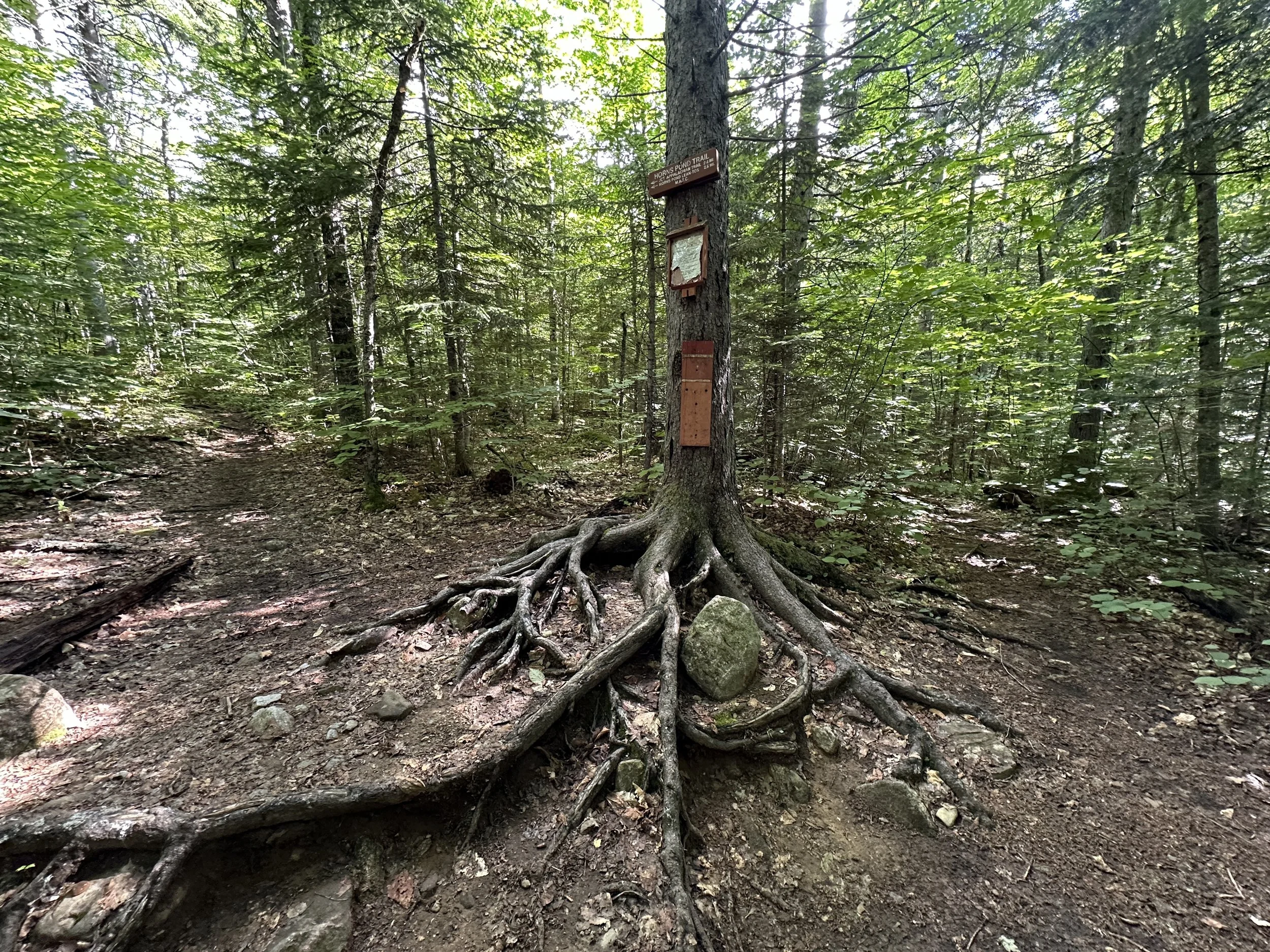
Horns Pond Trail + Fire Wardens Trail junction
The Fire Warden Trail remained well defined, with overall solid footing despite increasing occurrences of roots and rocks to step over or around - a seemingly standard, very pleasant, east coast hiking trail! As the pitch increases, more rock steps fill the steepening slope; we remarked about the incredible amounts of old trail work of the Fire Wardens Trail - in some sections, rock staircases fill the treadway upslope, as far as one can gaze. Before long, we encountered the Moose Falls Campsite, which offers a wooden outhouse, and an upslope water source.

Beyond the Moose Falls campsite, the trail becomes steep and rugged!
As we continued up the rock-step-lined hillside, views began to appear over our shoulders, always encouraging us to press-on, the various towers atop Sugarloaf Mountain now appearing at similar altitude, across the valley. During our trek, ground water seeped from trailside moss and boulders, but never dripped enough to soak a boot. Knowing the ridgecrest was tangibly close, we began passing wooden tent pads; two or three of which were visible, none occupied.

At the Bigelow Col
In the Bigelow col, signage warns hikers of the fragile ecosystem in which they will be soon encountering, explaining the necessity of remaining on-trail as to avoid trampling these slow-growing, high elevation, flowering, alpine plants. Aiming for Avery Peak first, we bore right (eastbound) onto the Appalachian Trail. Now following white blazes, we quickly transitioned onto jagged boulders and moderately rugged terrain, during which we employed hands for sure-footed balance - a slip at 4,000-feet is never a welcome option.
Beyond the locked Ranger cabin and a small, sign indicating a freshwater spring (which must have been off-trail, we did not easily locate), we quickly rose onto the western shoulder of Avery Peak; over our shoulders, the craggy knob of Bigelow’s West Peak dominated the skyline. Over several brief peaklets, the rocky pathway rolls into the alpine zone; we welcomed the slight breeze as it whisked any lingering black flies from our faces.

Summit of Avery Peak with Flagstaff Lake behind
The views from the bare summit of Avery Peak are simply breathtaking, some of my favorite from any of the Maine mountains I have scaled: the western ridge of Bigelow Mountain is craggy and sharp-pointed; to the east, Little Bigelow appears as a cresting, forested wave, separated by the deep, Safford Notch; views southward offer up glimpses of Sugarloaf, with Abraham’s alpine clearly visible behind; the rolling ridgeline of Crockers are there to greet as well; toward the north, however, the sweeping view is dominated by Maine’s fourth largest body of water: Flagstaff Lake, which stretches east to west, invariably wrapping partially around the Bigelow massif - just an absolutely breathtaking vista from 4,088’.
After visiting the old, stone foundation for the dismantled fire tower, and locating several USGS survey benchmark discs, we read several other plaques around the summit area and carefully retraced our steps to the Bigelow col - we had a long ridge walk ahead!

Looking back on Avery Peak from Bigelow’s West Peak
Farewell, we said once again to the Fire Warden Trail, continuing along the AT southbound, the trail wastes no time before becoming impressively steep and rocky, while enroute to our next 4000-footer of the morning: Bigelow’s West Peak, at 4,150’ (4,145’ by more recent measurements). A rocky climb of about 270’ brought us to the open, rocky summit of West Peak, which afforded our first glimpses along Bigelow’s western spine: a long, forest ridgecrest with the two, symmetrical Horns rising tall - our next destination.

Summit of West Peak holding my snack of Muir Energy
Following scree and rock walls through the fragile alpine zone, we dropped down steeply, working around rocky bulges in the summit cone, eventually re-entering the beautiful spruce-fir forest for an 1.8-mile stroll along the narrow ridgecrest. Initially, a steep, precipitous, forested descent, the footpath soon mellowed to a steady, rolling ramble through gorgeous softwoods - most of which had been unmarred until the ferocious Hurricane of 1938, then by subsequent storms and high winds. Regardless of its jarring history, this ridgecrest was draped in a blanket of moss, and simply stunning to stroll along - even moose evidently found this to be a favorable place to call home or escape summer heat.

Stunner of a forest along the Bigelow Ridgecrest!
Several restricted views southward can be had along this forested ridge, but overall, it seems very secluded. Just prior to beginning the final ascent (or so we thought) of our trek, a sliver of window overhead opened up in the forested canopy, to offer a westward glimpse, framing the cone of South Horn - which appeared much steeper and higher of a climb than we anticipated. Once actually on the ascent, the terrain passed rather quickly, thanks to solid footing and a fantastic trail bed of boulders which act as steps. Any look back toward the West Peak, from which we had just trekked, made the 4,150’ peak appear much more pronounced and sharper than we could have imagined - the Bigelow’s are truly a magical mountain range, in our opinion.

West Peak from South Horn
Greeting a fellow hiker atop the South Horn, he inquired whether we had intended to visit the North Horn, we did not today; “That climb is a THING!” he exclaimed. The sentiment solidified our plans of continuing back to our Subaru for a good, long soak in some mountain streams, post-hike. With a farewell to our new, jovial, hiking friend, we quickly made the 0.5-mile descent to Horns Pond atop large, rock steps - again, the distance flew by as we carefully bounced down the rock staircase.
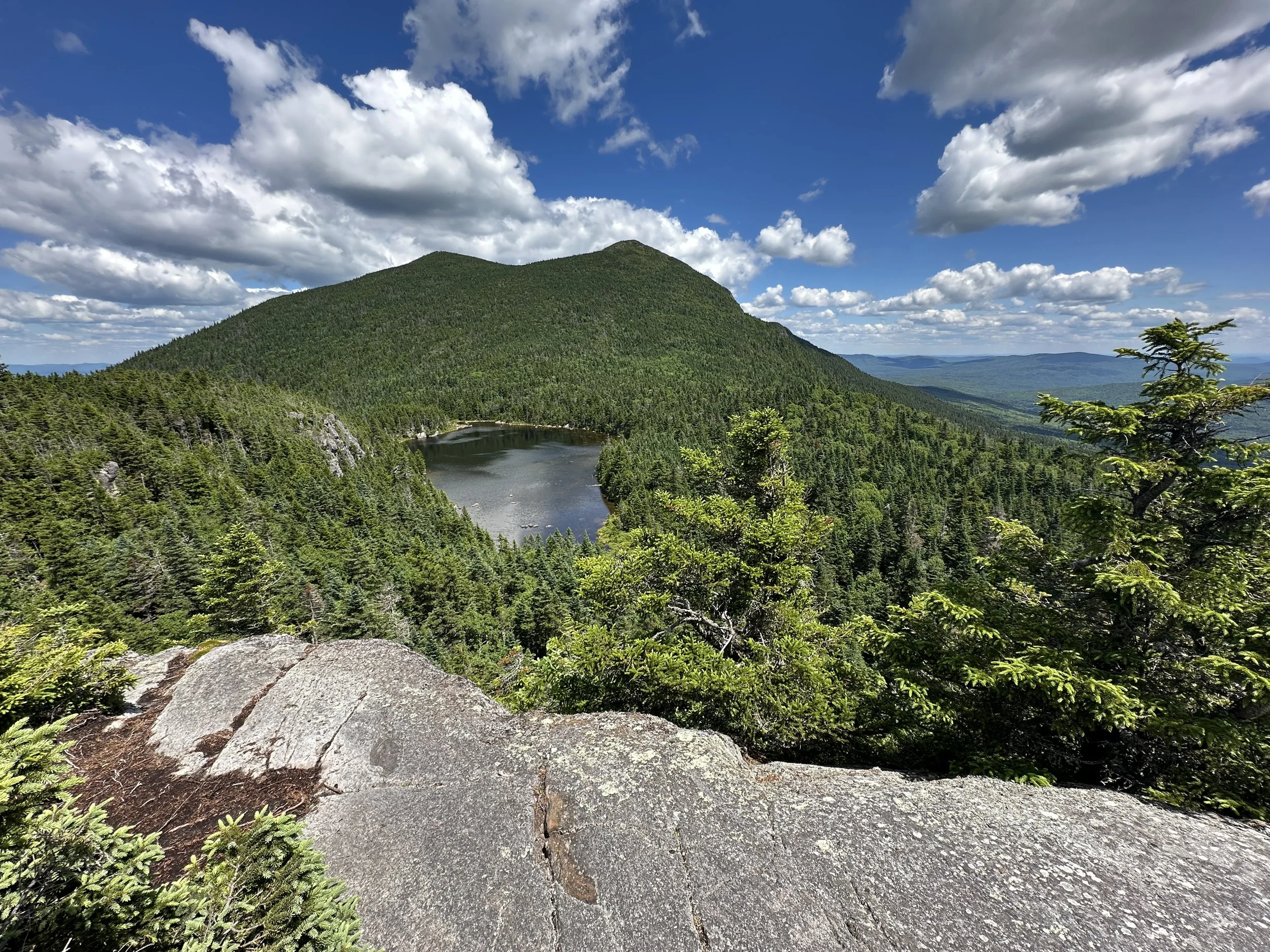
North + South Horn with Horns Pond from the AT
I recalled the day-use and camping areas well, as we navigated around Horns Pond, the body of water shimmered through the trees; we had no interest, or real need to visit today, with plenty of water packed for the descending miles. After consulting one of the hand-drawn signs, which colorfully illustrated the general, Horns Pond recreation area, we chose to proceed along the Appalachian Trail - as opposed to the Horns Pond Trail which I had descended five years prior - recalling the horrendous blowdown patch that was encountered, although, I assumed that devastation would likely be cleared from the pathway by now. We chose the AT south, also, assuming the increased traffic from thru-hikers might ensure better footing, allowing for a quicker, easier descent over the maintained footpath.

Getting rugged on the Appalachian Trail!
Upon leaving the restful day-use area behind, we were immediately greeted with the sight of a steep cleft of mossy rock. Luckily, footing remained good while scrambling the several steps of steep chimney-like incline. Several signed Lookouts exist just several rods off the AT, while enroute to its high point at 3,380’, known on some maps as Horns Pond Peak; these lookouts offer a stunning glimpse eastward, to a birds eye view of Horns Pond with the twin cones of North and South Horns poking up.

Bigelow Range Trail + AT junction
Upon descending the Appalachian Trail on the southwestern aspect of the minor peak, we soon found ourselves dropping steeply through rocky chasms with a mossy boulderfield surrounding. What a sight - and very unlike the Bigelow Ridge which we had hitherto trekked earlier in the morning! As elevation was lost along this side of the ridgecrest, we traipsed through several scenes of blowdown as well. Thankfully, all toppled timber had been cleared from the path - this left me curious whether, perhaps, the same storm had devastated the Horns Pond Trail, which I had descended five years prior; the appearance of toppled spruce appeared to be an appropriate age for this assumption.

Soft paths of the lower AT
Around several small house-sized boulders, the trail meandered hither and thither, eventually meeting the eastern terminus of the Bigelow Range Trail. From this well-signed junction, the Appalachian Trail passes west of an old, boggy, beaver tarn, affording a glimpse back northeastward, toward the forested ridge from whence we had descended. Footing along the AT quickly improved; now, following what appeared to be an old tote road, the surrounding forest began to transition back to a mixed canopy of both soft and hardwood.
As the grade tapered further, we passed several boardwalk bridges, soon encountering the Cranberry Stream campsite, which was also unoccupied on this weekday ascent. Trailside, a tributary to Jones Pond was incredibly inviting during this warm, summer day. Opting to save our cold-soak for once back at the trailhead, we pressed on through lovely, spruce woods - the trail offering a pathway so fine, we could press the speed into a hasty trot.

Hiker register box along the Appalachian Trail
Rolling along the lower mountainside, an MATC hiker register box, with several other minor tributaries were passed before encountering a major crossing of Stratton Brook. Luckily, a fine footbridge (Dick Brown’s Bridge, according to signage on the southside of the brook) afforded us an easy route across. The remaining bit of Appalachian Trail rolled gently through the hillside for 0.15-miles, crossing the earthen, Jones Pond Road (Cranberry Peak Road on recent maps) along the way.

Footbridge over Stratton Brook
Swinging over a final, wooded knoll with an old, hiker kiosk and register, our Subaru was finally insight! By now, the mid-day heat was drifting into the forest; deer flies were also showing great interest in any exposed skin, so we hopped in the car, rehydrated with cold tea, and bee-lined for Rangeley Lake, where cold water had never felt so refreshing. A fine day traversing a superb ridgecrest, indeed!
Overall stats for the day:
12.7-miles
7hr 38 minutes
4,678’ elevation gain
Avery Peak - 4,088’
Bigelow West Peak - 4,150’
South Horn - 3,805’
Horns Pond Peak - 3,380’

2000-miles of Appalachian Trail, what a FEAT on foot!