
Cranberry Lake 50
While working on trekking the paths featured on the Northeast Ultra 8, this 50-mile loop around Cranberry Lake weighed heavy on my mind for many years. Located in the western Adirondack Mountains of New York State, it was, for me, not only the furthest commute, at roughly 5-hours one way, but, obviously a distance of 50-miles on foot, through remote, mountainous terrain was honestly, a bit intimidating. For many years, I would go back to the map to begin planning an attempt of this loop, find all the YouTube videos and past trip reports, searching for that one, hidden detail that would indicate that, “yes, I can do the Cranberry Lake 50, no problem!”

First trail marker spotted while driving into town!
Having completed a timed foot race (Beebe Farm Ultra; Dorset, Vermont) back in 2019, of 52-miles in 12-hours, I figured the distance was doable, but a lot had happened since encircling that overall, flat, gravel track. Not only had my left foot been ran over by a dislodged boulder while bushwhacking, but I was still recovering from a rather significant knee injury (2022), both of which were hovering somewhere around 95%, in my mind.
With the idea that now was the time to finally attempt this 50-mile trail run (hike, jog, whatever speed it would take), I had not only a window of fine weather, but also time on my hands to make the long commute westward, to New York for the ramble.

Exploring my boat launch home for the night
In the weeks leading up to my attempt at the Cranberry Lake 50, the northeast had seen a fair share of torrential rains and significant flooding, being a western New Hampshire resident, I saw firsthand, the devastation mother nature was inflicting upon roads, bridges, and trails of Vermont; I hoped New York fared well. Checking reports on the Cranberry Lake 50 Facebook group afforded minimal insight, yet the minimalistic reports still indicated to me that backpackers were at least out on the trails, making the loop in their prescribed, 2 to 3 days. Finding AllTrails reports to be of a similar, lackluster detail and usefulness, I was able to conclude that the Cranberry Lake trails were at least able to be hiked.
In prior years, I had always planned on packing gear into a smaller running pack or vest; for this 2024 attempt, I brought much more gear, packed into a hazard orange, 28-liter Gregory Alpinisto pack. Lined with a waterproof trash bag, I stowed a Gore-Tex shell, 2 pairs of spare socks, gloves, beanie (in case speed was slowed to a literal crawl), 2 extra tech shirts, and extra running shorts. Along with my full-sized medical kit for longer hikes, I packed a fire-starting knife (flint and striker concealed), Sawyer Mini water filter, toilet paper, map + compass, Garmin InReach, 2 tins of balm for chafing, and several buffs and handkerchiefs for various reasons.
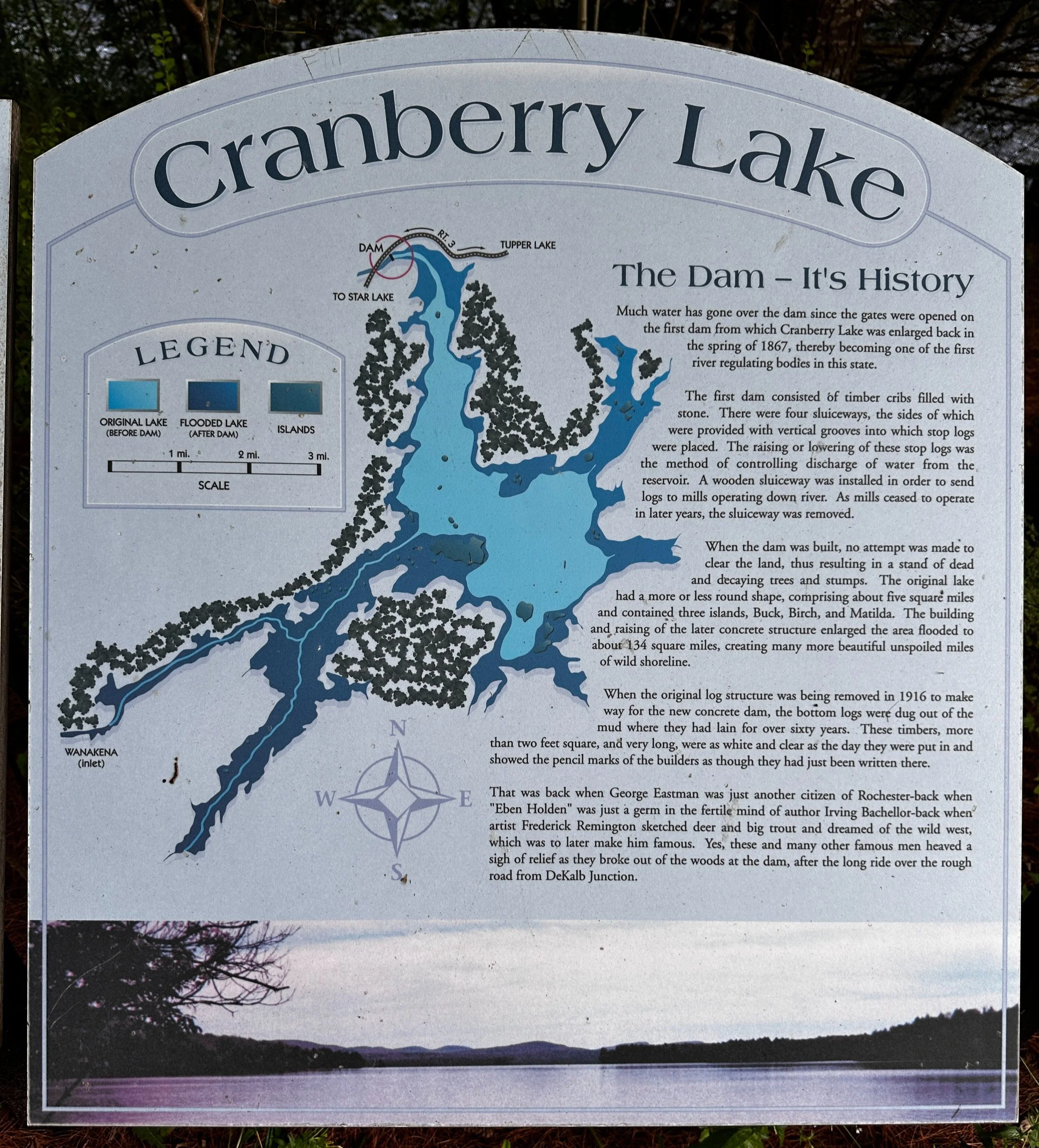
Brief history of the Cranberry Lake dam
While ultra-light had clearly gone out the window, I wanted to be totally prepared for the unexpected - I was aiming to trek 50-miles alone in a wilderness I had hitherto not yet seen. A 3-liter water bladder was filled; I brought 2 potatoes, 1 sandwich with Muir Energy + peanut butter, a bag of peanuts + pumpkin seeds, 1-pound of pitted dates, 3 separate pouches of various Muir Energy, several ginger chews, and as a first for me - 1 small pouch of pink Himalayan salt; generally, this salt goes in coconut water for long outings.
Along the drive to the trailhead in NY, I stopped at REI for a fresh pair of Injinji socks, toe socks which had been wore out and never replaced, I used these in the past on many longer distance runs, including the 32-mile Pemi Loop, and the 12-hour Beebe Farm Ultra. Wanting to give myself the best shot at comfortably completing this challenge blister-free, I opted to give another pair a shot - in hindsight, this was (in my opinion) a critical piece of gear used for the Cranberry Lake 50.

Beginning out of Wanakena, 50-miles to go!
From the east, I passed all the familiar places: the old star forts at Crown Point, the twin Cascade Lakes entering the High Peak region, Lake Placid and Saranac Lake - eventually arriving lakeside at the Cranberry. What a rush it gave me to finally see those blue “CL50” discs along the Route 3 road portion; stopping at the Lakeside General Store, I picked up an overpriced bag of ice to keep watermelon and other refreshments cold while on trail.
Initially, I had planned to car camp at the trailhead on the East Connector Trail side, but upon reading recent trail reports and learning of the beaver activity just south of Wanakena, I soon altered my plans to hit that section last. Taking a drive to the boat launch and hydroelectric dam area near the northern tip of the lake, I was greeted with “overnight parking” signs, and a large parking lot - my stealthy home for the evening. To my delight, the boat launch area (no parking there) offered two porta johns which would accompany my morning routine of coffee and muscle stretching just fine.

Morning strolls along the West Connector Trail
After a hot, and not-so-restful night of sleep in the rear of the Subaru, the morning routine began at 2am, under a starlit sky. Humidity was better than it had been recently, and temps lingered somewhere in the low 60’s, I could deal with that. Thankful for the bathroom before getting on trail, I drove the 10-minutes to the sleepy town of Wanakena, to park at the tennis courts, which I had read about from past reports on Reddit.
As morning haze rolled in from this western finger of Cranberry Lake, I could see more blue discs with an arrow indicating the way; I would begin at 4:05AM by crossing the lake on a narrow footbridge, thus entering the heart of town. Here, I was delighted to spot with headlamp beam, a massive CL50 blue disc replica adjacent to the bandstand gazebo; if, or when I finished this trek, certainly I’d celebrate with a photo at this spot.

Massive birches adorn the soft path
Through town, I trekked to get the blood flowing and joints limbered up; it was hard to believe I was finally on this path, now set to walk-run for 50-miles. From side-to-side, my headlamp swung, searching for any movement or eyes in the water or forest found roadside; only one set of green eyes tracked momentarily, I treated it as a bear and talked to it, to let it know I also knew it was there; there were no further encounters.
Entering the Ranger School area, I could turn my lights off as the compound was well-lit, the seemingly endless row of black trucks with “Police” inscribed on the windshield set me at ease, NYS Department of Conservation vehicles. Soon, the CL50 path diverged and entered a wide, old, forest road as it continues around the edge of the lake; this section, known as the Peavine Swamp Trail always sent a chill up my spine during the planning phases - it just sounds super wet. While it had several small, muddy spots, most was dry enough to be walked right over.

Hydroelectric dam from the foot bridge
Several ski trail loops diverge from the main chunk of CL50 and Peavine Swamp Trail, all trails seemed to be well-marked during this trek. Rolling along through a beautiful, northern hardwood forest, the surroundings transition to brief patches of tight, beech saplings with a low canopy - this was very interesting to see, however, many of these sections offered waist-deep grasses which were dripping with morning dew; overall: legs got wet, but feet remained dry.
Somewhere around the start of the West Connector Trail, the headlamp was no longer needed; finally, I could see out and into the surrounding forestscape: more, lovely, northern hardwoods along a rolling terrain. Some stunning rock stairs comprised the footpath as it dips downslope to cross several small drainages. Overall, I was pleased with the moderate, 16-18-minute/mile pace which began this long loop around Cranberry Lake.

Morning shuffle along Route 3
Nearing 9-miles into my morning, I reached the boat launch parking lot where I had overnighted prior to beginning this wild ramble. All morning, while gazing trailside for movement or eyes lingering in the forest, my mind performed mental math, or “ultra-math”; constantly thinking of the “what-ifs” - if I continued at a given pace, how long would it be until I finished the loop, versus, if 30-seconds were added or subtracted from each mile - perhaps a nervous habit, it’s certainly a way to keep the mind occupied during these longer stints.
Breakfast consisted of 9-grain bread with cashew Muir Energy and peanut butter, solid food for the coming miles. I had begun the road section alongside Route 3, as highway vehicles now passed, departing their compound across the street. Several other morning runners exchanged greetings as I shuffled eastward; everything felt fine, and I wanted to keep it that way.

Along the West Connector Trail
Finally, departing the asphalt roadway, the path beyond the Gilbert Tract trailhead began along the Eastern Connector Trail - ferns turned the old, forest road into a viridescent tunnelway. Stunning, bouncy boardwalk sections moseyed through a boggy spruce land, mosses and other low vegetation lined trailside - this was a truly beautiful section of pathway for many miles.
From girthy spruce trunks, the CL50 footpath meandered onto a red disc blazed snowmobile path, which appears to be an old railroad grade on older maps. Straight as an arrow, in sections, the footing was fine to encourage a quicker pace for the coming miles. Upon reaching several tent sites, the footpath was totally flooded in one section by recent beaver activity; the old, wooden bridge was afloat amidst the flood waters; crossing atop well-placed sticks and logs, here, toes finally got wet for the first instance, yet thankfully never became problematic.

An inaccessible foot bridge
Passing Hedgehog Pond, the footpath soon meandered around log-choked cove, then followed an edge of Cranberry Lake briefly, before beginning the long, wooded stretch toward subsequent ponds easterly. Finally, the sun began to illuminate the surrounding forest, shafts of light broke through the hardwood leaves, working to dry sweat-soaked running clothes. Between more significant meals of bread or potato chunks, I would sip water - this was when I began dipping into the pouch of pink Himalayan salt, which I carried; thoughtfully planning and spacing out the salt intake - each time I consumed any, I would feel a slight boost of energy flood my leg muscles. While this was a first for any of my longer distance treks, the routine proved indispensable, allowing me to continue onto mile 50 with zero cramps nor any musculature issues of any sort.

Curtis Pond from the Dog Pond Trail
Terrain grew rocky, rugged and full of glacially fractured and deposited boulders - some several stories tall found just off trail - what a unique landscape exists in these woods! Several beaver dams were spotted as the trail crossed several outlets; more, picturesque campsites were found just off trail, a magical spot in these seemingly desolate woods. Around Dog Pond, the trail grew close-to, but never quite reached the water’s edge; I had begun ruminating over the need to filter water soon.
Nearing mile 23, my thoughts could not even comprehend that I had yet to reach my halfway mark, but as the footpath dropped in elevation, it made a sharp, westwardly swing and joined another old, forest road, intended, evidently, more for hunters than loggers. Several piles of what I assumed to be haphazardly dumped trash were passed in the Forest Preserve, but upon checking post-hike, these are reported to be remnants of old hunting camps; old, rusty stove parts, used canisters, and even an old lantern frame can be found trailside. The going was remarkably smooth through here, for some time, I was able to switch my mind off, and simply watch the miles click by on my watch.

Pleasant miles through the Forest Preserve
Hitting mile 25 was significant, marking what would be the halfway point of my journey - still, I could not believe another 8-hours of foot travel lay ahead; at least I was feeling good, and still had no concerns aside from obtaining water. Around the Chair Rock Flow inlet, I finally had a chance to filter quick flowing water, albeit brown with tannins and warm from sunlight. Mosquitoes turned me into lunch as I squeezed 2-liters into the 3-liter bladder; with a bit of mental math, and knowing I was now over halfway through the trek, I thought that water stash might get me back to the car.
Quickly, I began sucking down water to make up for the past several miles, where I had gone light on the intake. Through more, rugged terrain, the path meandered along a boulder-strewn landscape, as if taken straight out of the Jurassic Park movie. It may have been between Spectacle and Olmstead Ponds where I encountered higher shorelines, and began following smaller, blue flags marking a herd path; before long, I found more CL50 discs, as if the trail crews were preparing for a reroute around the beaver activity. Here, the path was narrow, and required looking ahead to spot the next flag or disc, just to stay on course.
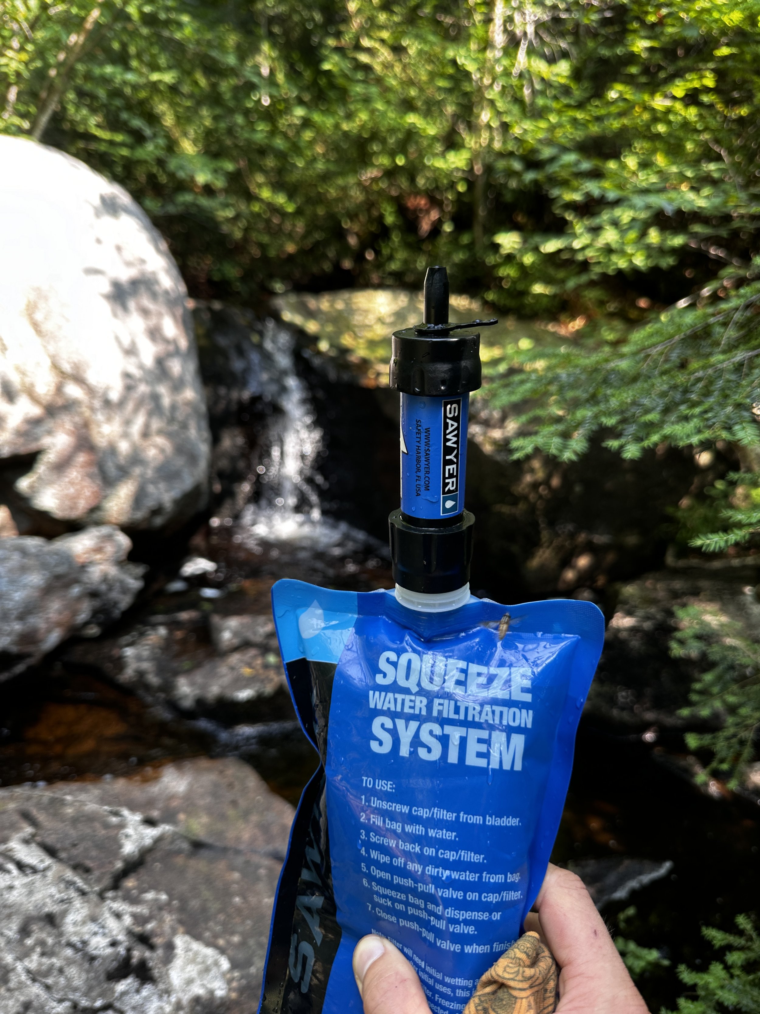
Water on-the-go, filtered from the waterfall
Between refueling, rehydrating, and taking in electrolytes, I found the narrow ridgecrest of Six Mile Creek Trail an absolute joy to traverse, it was completely renewed scenery; massive pines had been cleared from the ridgeway, forming a narrow tunnel of passage, until reaching the junction for Cowhorn Pond and its waterside lean-to.
Shortly after passing Cowhorn Pond, I came upon a junction which indicated my car to be either 5.7-miles distant - by short-cutting (giving up on) the CL50 - or I could proceed on my original route, the +13-miles through unknown territory and no doubt, more beaver activity. Knowing I was again low on water, I had serious considerations of making the quick trek back to my awaiting car, where I had stowed a half-gallon of chilled water.

Along the Primitive Corridor - really not so bad!
Remembering what it took to get to that exact spot, the desire to call my 50-mile loop, thankfully, did not persist; conveniently finding an ice-cold spring at the base of Cat Mountain (nearing Glasby Pond), I filled up several liters, took on more mosquito bites, and filled the 32oz filter pouch to sip on-the-go. Finally, cold, refreshing water! With each sip, invigorating life seemingly poured back into my mind and muscles - I was fueled, hydrated, and ready to crank out those remaining 10-miles. Just the thought of “one-fifth remaining” was enough to bring me down, but the surrounding forest had now become significantly older. Despite signs of hurricane devastation, the downed pines were absolutely massive in diameter - what a sight, an absolute blessing to find myself trekking among these giants!

Soggy footing along the High Falls Loop Trail
Before long, I began seeing 15-minute/miles drop to 14, then 13 - the speed felt great, smooth, along those final miles of the High Falls Loop, thence back to my car. Entering the signed “Primitive Corridor” section, the pathway became rather grassy, even proving tough to spot any foot placement, although, the scenery was out of this world! Traveling alongside a seemingly blackened streak of Oswegatchie River, most crossings were initially atop lovely, wooden bridges, some simply on patches of earth as water trickled underfoot.

Altra’s filled like balloons with bog water
Before long, the grassy, river walk joined an old woods road, passing several signs indicating nearby campsites; with about 6-miles remaining, I began following the CL50 discs into flooded terrain. Crossing the base of several, precarious beaver dams, the first several were rudimentary; however, upon spotting a highly inundated trail ahead. Initially, I attempted to bushwhack around, but the dense, prickly, spruce forest said otherwise. With several fresh gashes, I returned to the trail corridor and told myself, “the only way out, is through”, and began through the deluge of calf-deep, warm, murky, bog water.
Splashing through, once trail runners had been inflated with bog water like balloons, there was no point in tip toeing any longer. No time was wasted at any subsequent beaver dam crossings - despite them reeking like ancient, rotten vegetation. The stench was gnarly, to say the least, but, at least forward progress was being made, and that’s all that mattered to me.

There is a trail here; along Skate Creek
Rejoining the derelict road corridor, I continued seeing 13-minute miles, even getting down to 11 minutes per mile briefly before feeling old injuries in my left foot were beginning to nag, backing off, I would still arrive to my car before my suspected 16-hour time.
During the final several miles, I consumed any remaining snacks: peanuts and dates, along with a packet of red raspberry Muir Energy, to bring some flavor to the party - I had a hunger that none of these meager nibbles could fulfill. Hitting mile 48, I encountered more calf-deep water - this was once again simply trudged through.

Exiting out of the Wanakena Primitive Corridor - Woohoo!
Mile 49: finding myself back amidst a sea of tall grass (I found zero ticks from these overgrown stretches), I adored the sight of Skate Creek, which transitioned into a full-on boggy pond as my final destination grew near. Around a corner, I encountered a kiosk and yellow gate: the start of the Wanakena Primitive Corridor. I had made it out the other side!
As I walked along the brief, gravel road, the tennis courts with my Subaru inevitably came into sight. The, now, lightweight pack was dropped alongside my car as a man passed by curiously asking if I had just hiked “the loop”; indeed, I had hiked the loop. What a day since that 4:05AM start; the worst mental game that, for me, any trek had ever become: fifty miles alone, completely inside my head, simply performing tasks to allow my body to continue covering terrain. Such a bewilderingly primitive act.

Car to car: Cranberry Lake 50, done
Not far away, I could hear the townsfolk clamoring at the bandstand area, gathered for a celebration of sorts, I supposed. Toward their direction, I shuffled, for my very own celebratory photograph with the gigantic CL50 blue trail marker; no one passed a glance as I stood proudly next to that comical disc. The fifty-mile trek I had dreamt of for so many years had been accomplished. During that time, I could not fathom attempting those brutal miles again (aside from a multi-day backpack); now, several days recovered: I think I can do it faster next time.
Overall stats for the day:
49.25-miles
4,875’ elevation gain
14-hours 51-minutes

Tired, satisfied, and ready for all the snacks